
Construction and earthworks drone volumes and monitoring
For earthworks and civil engineering contractors, project managers and civil design offices: I measure by drone, across the whole site, the volumes cut and filled, the earthworks remaining against the design, stockpiles and the condition of the ground.
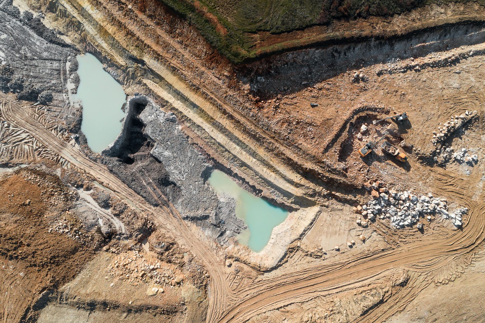
Why survey a construction site by drone?
One flight covers the whole site and measures millions of points, where a ground survey takes a few cross-sections. Volumes follow the real ground, embankments, benches and formation levels included.
The RTK drone and check points measured with an RTK GNSS rover on a tripod tie each survey in to within a few centimetres. Successive surveys line up: the difference between them measures the earth moved, which you can invoice, check or justify.
The same survey serves the works manager for monthly valuations, the design office for comparison with the design and the client for tracking progress.
What I measure, from the first bucket to handover
- Cut and fillvolumes moved between two surveys, for monthly progress valuations
- Comparison with the designcut and fill remaining, as a map and by zone, earthworks balance
- Site stockpilestopsoil, imported materials, spoil to remove: the volume of each heap
- Dated condition surveybefore works, at the end of a phase, at handover: a measurable record of the ground
- Progresssurvey after survey, how the earthworks advance across the whole site
- Platforms, embankments, haul roadslevels, gradients in %, embankment slopes, long and cross sections
Earthworks remaining, point by point
The viewer compares the survey with the design surface every 20 cm: blue shows what is left to cut, red what is left to fill. You read volumes, earthworks balance and figures by zone in the online space.
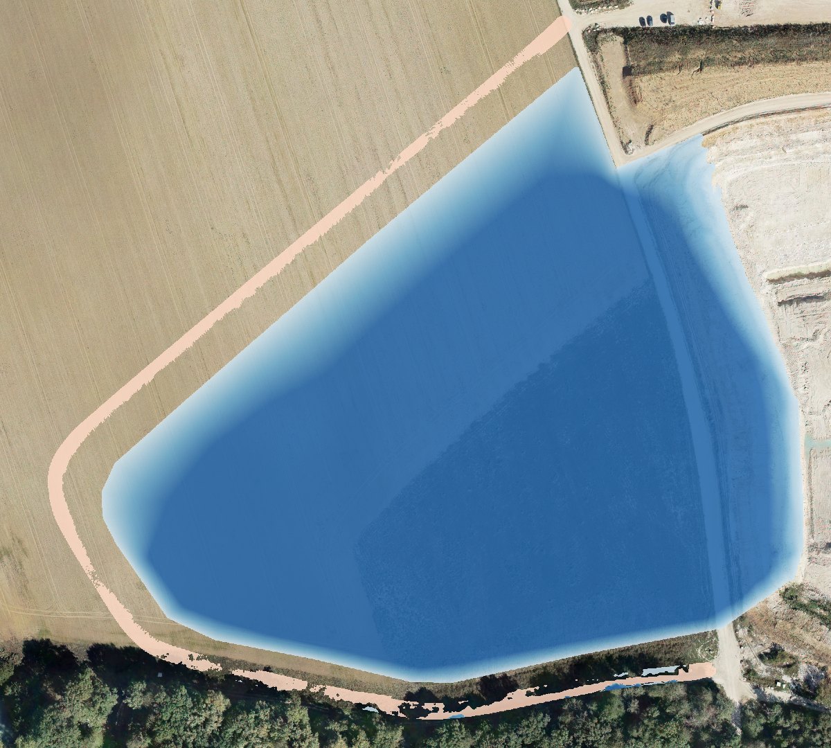
- Cut remaining
- 984,500 m³
- Fill remaining
- 1,700 m³
- Surplus material
- 982,700 m³
- Area compared
- 5.7 ha
The example design: a pit extended into the neighbouring field, 10 m from the diverted haul road that runs around it (7 m carriageway, long gradient limited to 7 %). The pit floor is at the level of the existing quarry floor, measured on the same survey; the slopes run from the crest down to the edge of the floor, gentle to the north-west, a steep face to the south. By zone: 791,100 m³ in the pit floor, 192,800 m³ in the slopes, 1,700 m³ of fill for the haul road.
I reconstructed it from the extension built later, visible on the aerial image used as the viewer's base map: its pit floor covers 96 % of the floor visible on the photo.
Design reconstructed for the demo on the real ground of a survey. Anonymised data: no coordinates, relative elevations.
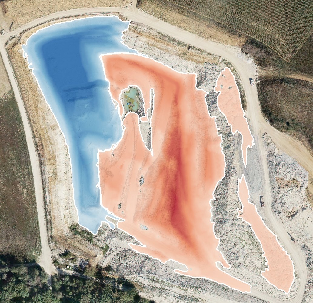
Between two surveys, what has been done
- Cut
- 90,500 m³
- Fill
- 87,700 m³
The same calculation drives progress valuations: from one survey to the next, the volume cut or filled, zone by zone.
Here, on the site's real data, 90,500 m³ cut on the west face of the pit floor and 87,700 m³ filled to the east. The gap with the volumes of the original deliverable stays under 0.5 %.
From flight to volumes in 48 working hours
-
01
Preparation
You send me the site boundary, its coordinate system and, if you want a comparison, the design surface or the previous survey. I prepare the flight plan and the area to be flown, and check the airspace constraints of the site.
-
02
The flight, planned with the site manager
I agree the time slot, the area flown over and the instructions for the crews with the site manager, under the rules of the flight scenario. The RTK drone flies parallel lines at constant height; on the ground, check points measured with an RTK GNSS rover on a tripod verify the tie-in. I then remove from the terrain model the plant on site during the flight.
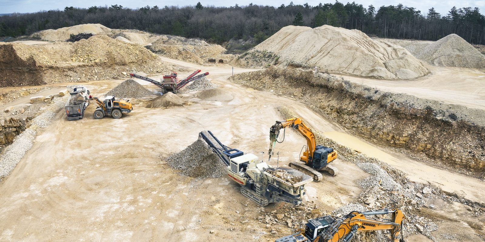
Plant, stockpiles and excavation faces: the drone surveys everything it sees, I sort it afterwards. -
03
Volumes within 48 working hours
I deliver cut, fill, comparison with the design and stockpiles within 48 working hours of the flight: in your online space, and as PDF and CSV for your progress valuations.
-
04
Full deliverables within 5 working days
Orthophoto, terrain model, point cloud, plans and files for your software follow within 5 working days. Every survey stays available in the online space, to compare with the next ones.
Up-to-date volumes, in your own tools
An online space for the site
Map, measurements, volumes, comparison between two surveys or with the design: you view everything in the browser, with no software to install, in a private space protected by an access code. Works manager, design office and client all see the same figures.
Volume reports
Cut and fill volumes, by zone and in total, difference map, stockpile sheets: as PDF for valuations and handover, as CSV for your spreadsheets.
Files for your software
Terrain surface as LandXML or 3D DXF for Covadis, Mensura or Civil 3D, point cloud as LAS, LAZ or E57, orthophoto and terrain model as GeoTIFF, plans as DXF and PDF: in the site's coordinate system.
Frequently asked questions
How accurate are drone volume calculations?
The RTK drone and check points measured with an RTK GNSS rover on a tripod tie the model in to within a few centimetres. The calculation uses millions of points, which matters on uneven ground. I remove tall vegetation and plant from the terrain model before calculation.
How quickly are volumes delivered?
I deliver volumes (cut, fill, comparison with the design, stockpiles) within 48 working hours of the flight. Full deliverables (orthophoto, terrain model, point cloud, plans) follow within 5 working days.
Does the site have to stop during the flight?
I plan the flight with the site manager: together we agree the area flown over, the time slot and the instructions for the crews, under the rules of the flight scenario. I remove plant visible in the photos from the terrain model before calculating volumes.
Which file formats are delivered?
Whatever your software needs: terrain surface as LandXML or 3D DXF for Covadis, Mensura or Civil 3D; point cloud as LAS, LAZ or E57; orthophoto and terrain model as GeoTIFF; plans as DXF and PDF; volumes as PDF and CSV.
Can the survey be compared with the design?
Yes. From the design surface (LandXML, 3D DXF or terrain model), I calculate at every point the difference between the surveyed ground and the design: cut remaining, fill remaining, earthworks balance, by zone.
Is authorisation needed to fly a drone over a construction site?
Drone flights are governed by European Regulation (EU) 2019/947. Depending on the risk, a flight falls under the 'open' category, with strict limits (distance from people, built-up areas…), or the 'specific' category: the operator must then be declared to the national authority (the DGAC in France) and fly under a standard scenario, such as STS-01, or with an authorisation. On sensitive and regulated sites, work is carried out under protocol.
A site to measure, a design to track?
Let's talk about your site, or try the demo: comparison of two surveys and earthworks remaining, on real data.
Olivier Lattuga, trained in photography and then a graduate of the EHESS, has spent fifteen years working with technical imagery and land. Based in Lyon, he works throughout France.
UAS operator declared to the DGAC (French civil aviation authority) — European standard scenario STS-01 (Regulation (EU) 2019/947) — flights under protocol on sensitive and regulated sites.